Zhygalgan collapsed limestone cliffs and landslide amphitheater in Mangystau, Kazakhstan

ZhygalganThe Fallen EarthTupkaragan Guide

Where a giant limestone caprock collapsed 50–100 m straight toward the Caspian Sea

Destination guide

How Zhygalgan collapsed—and why geologists love it

Roughly 110–150 km north of Aktau on Tupkaragan Peninsula, kilometers of coastal plateau slid seaward over soft clay layers—exposing tumbling monoliths and 10–15-million-year-old mammal trackways.

Approaching Zhygalgan (often spelled Zhygylgan or Jygylgan) across the northern steppe gives zero warning: flat plateau grass ends abruptly in a colossal horseshoe abyss spanning several square kilometers and plunging 50 to 100 meters down toward the Caspian Sea.

Here a thick upper slab of ancient marine limestone rested atop softer, water-lubricated Miocene clay strata. When groundwater seepage and Caspian wave undercutting weakened the clay cushion beneath, massive cliff sections fractured and slid downslope like frozen waterfalls of stone—giving the site its Kazakh name, “Fallen Earth.”

Inside the chaotic bowl of house-sized slabs and seasonal shallow lakes lies one of Mangystau’s quiet paleontological surprises: tilted layers of hardened ancient lake silt preserving 10-to-15-million-year-old fossilized animal footprints, including prehistoric three-toed horse ancestors (Hipparion) and saber-toothed predators (Machairodus).

Located approximately 110 to 150 km north of Aktau on the Tupkaragan Peninsula beyond Fort-Shevchenko, Zhygalgan pairs seamlessly with nearby coastal bays, Shakpak-Ata Underground Mosque, and Kapamsay Canyon on coastal 4×4 day trips or longer Mangystau expeditions.

Written by Sergey Khachatryan, local Mangystau guide

Sergey has explored Mangystau routes for 21 years (since 2005), first as a hobby and now by guiding travelers through the region’s desert routes. His planning focuses on realistic driving times, safe 4×4 access, weather, and the best light for each place.

Aerial coastal view of Zhygalgan crescent cliff dropping into the Caspian Sea
The crescent limestone amphitheater tumbles step by step toward bright turquoise Caspian waters.
Aerial view of fractured limestone landslide cliffs inside Zhygalgan
Massive detached limestone blocks stalled midway down the sloping clay terraces.
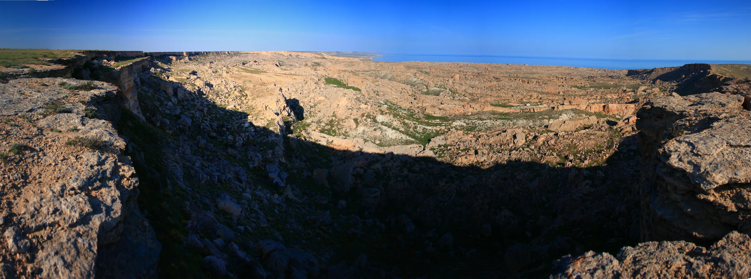
Wide rim panorama looking across the entire Zhygalgan Fallen Earth depression
Wide panorama along the upper rim revealing kilometers of collapsed boulders and coastal lakes below.

Route experience

How to explore Zhygalgan safely

Combine wide-angle views along the plateau lip with an optional guided descent into the monolith field.

01

Drive the Tupkaragan coastal road

Routes run north from Aktau via Fort-Shevchenko or cut across rough limestone steppe after Shakpak-Ata—unpaved coastal tracks demand high clearance and proper 4×4 tires.

02

Scout fissures back from the cliff lip

Strong gusts sweep off the Caspian Sea across deep surface cracks parallel to the rim; never stand on undercut limestone shelves without checking ground stability first.

03

Descend to the boulder terraces & fossils

Guides know safe paths winding between giant slabs down toward shallow seasonal lakes and the silt layers holding ancient mammal prints (observe without chipping or removing stone).

Safety, seasons & pricing notes

  • Zero guardrails or rescue infrastructure exist—watch wind strength, stay back from tension fissures, and wear sturdy ankle-supporting boots if hiking down.
  • Standard 4×4 pricing: €450/day per vehicle (up to 3 guests), e.g., €150/person/day when 3 guests share one 4×4.
  • Multi-day desert stays use tent camping only (no yurts), with no fixed toilets and shower depending on water availability; Starlink Wi-Fi is conditional.
  • Airport transfer is extra on request; medical insurance is arranged by the guest.

Tupkaragan day trip vs. 7-day circuit

Because Zhygalgan sits on the northwestern peninsula rather than the southern Ustyurt road, it is often missed by tight 3-day Bozzhyra itineraries—making it a standout highlight for travelers with an extra day in Aktau or on custom coastal photography routes.

Afternoon sun paints the eastern amphitheater walls warm amber while turning the Caspian Sea behind it deep sapphire.

FAQ

Zhygalgan FAQ

Distances, geology, fossil history, and coastal safety notes.

How far is Zhygalgan from Aktau?

Zhygalgan sits roughly 110–150 km north of Aktau on the Tupkaragan Peninsula, usually around 2 to 2.5 hours by 4×4 depending on the coastal track chosen.

Why are animal tracks embedded in stone inside Zhygalgan?

10 to 15 million years ago, shallow ancient lake beds recorded the footprints of Hipparion (early three-toed horses) and Machairodus (saber-toothed cats); when the cliff later collapsed, tilted slabs exposed those layers.

Is it safe to fly a drone or stand close to the edge?

High coastal winds funnel cleanly up the bowl, so stand well inland from fractured overhang slabs and monitor sea wind speed carefully before launching drones.

Can you swim near Zhygalgan?

Summer visitors occasionally stop at rocky coastal bays or sandy Tupkaragan beaches nearby, while the seasonal lakes inside the collapse itself are brackish mud-flats.

Can a regular sedan reach Zhygalgan?

Once you leave Fort-Shevchenko asphalt, sharp limestone tracks, sand patches, and uneven gullies require a proper 4×4 vehicle.

What pairs with Zhygalgan on a 1-day coastal route?

Blue Bay (Golubaya Bukhta), Saura turtle gorge, Shakpak-Ata, and Kapamsay Canyon all sit on the same Tupkaragan Peninsula loop.

Plan Zhygalgan

Visit Zhygalgan Fallen Earth on a coastal 4×4 tour

Send a tour availability request with your preferred dates and group size (we usually reply within 24 hours—This request checks availability first, not instant booking confirmation).

Ask About Availability